A30 Bodmin to Indian Queens Improvement |

86.2% |
Project Team:
Client: Highways Agency
Client Representative:
Mouchel
Main Contractor:
Alfred McAlpine (acquired by Carillion 2008)
Designer:
Scott Wilson
Client Environmental Advisor: RPS
Scheme Details
Cost of Scheme: £93million. Construction cost: £60million
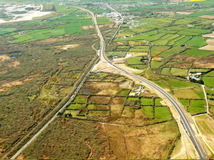
Length of new dual carriageway: 11.5km (7 miles) also 6.5km of side roads.
Work Started: July 4th 2005. Mainline Completion: July 11th 2007
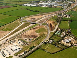
New Structures: Three over-bridges / four underpasses / two grade separated junctions.
Earthworks: 970,000 cubic metres of excavation and 700,000 tonnes of imported china clay waste of which 230,000 tonnes were supplied as surfacing materials
Background
Schemes to improve the A30 between Bodmin and Indian Queens have been examined since the 1970s. Large seasonal variations in tourist traffic resulted in severe congestion, affecting communities and businesses, and the route of the old A30 bisected a nationally important piece of Moorland designated a Special Area of Conservation (SAC) and a Site of Special Scientific Interest (SSSI).
An obstacle to heavy goods vehicles, the low ‘Iron Bridge’ rail crossing, forced lengthy diversions along minor roads and severe delays occurred regularly across the region resulting from collisions with the structure, while low visibility at busy side roads caused frequent accidents.
Traffic volumes are forecast to increase from 25,000 to 37,000 vehicles per day by 2022, with particular problems during the summer months. As most of the A30 from Exeter is now built to dual carriageway standards, the single carriageway between Bodmin and Indian Queens presented a major bottleneck.
 |
|
Benefits of Early Contractor Involvement (ECI)
The A30 Bodmin to Indian Queens scheme was one of the first to be procured on an ECI basis. Although ECI is now the norm, in 2002 it was considered a dramatic step, showing the Highways Agency’s commitment to improving value through effective partnering and proactive procurement.
The ECI process has allowed the project team to develop and grow in a trusting and mutually respectful environment. Continuity of delivery team staff has resulted in a dispute-free scheme, where all members have genuinely worked together with a common goal and common objectives.
Specialist supply chain partners were brought to the team early. Proactive partnering with the supply chain resulted in no disputes and early settlement of final accounts.
Central Cornwall is home to a large china clay quarrying industry, which produces granite-based sand and gravel as a waste product. 98% of the imported stone was sourced using this waste as secondary aggregate. Bardon Contracting, Bardon Aggregates and Needham & Cullen (all part of the Aggregate Industries Group) used their joint expertise to maximise the use of china clay waste.
Construction Design Rationale
The key objective was to build the new road with minimum impact on traffic flows through and around the scheme. The construction plan allowed for the building of a permanent diversion at Mount Pleasant and the early opening of the two junctions at Innis and Victoria.
As part of the Mount Pleasant section, an underpass connected the existing Roche Lane junction with the new diversion. This allowed earth-moving traffic to pass from one end of the scheme to the other without impacting on users of the existing A30.
Initially, at the Innis Downs junction, the preferred route indicated two bridges with the intersection overlaying the existing roundabout. The project team developed the chosen solution to build a top-down bridge at ground level in the middle of the existing roundabout and, subsequently, the two dumbbells, with minimal disruption to the travelling public.
At the Victoria Interchange, the preferred route crossed the existing line in the proximity of a required interchange. To minimise disruption, the interchange location was moved to allow full off-line construction, with disruption only experienced during night-time tie-in work.
At the Indian Queens tie-in, the alignment was designed to allow part-construction of the widened embankment and the construction of a temporary alignment to facilitate full construction with little impact on the travelling public.
 |
|
Heritage
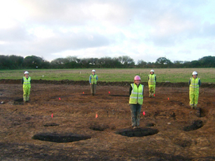
Site clearance was completed under expert supervision, as was the archaeological investigation, where, on land near the hamlet of Belowda and at Deep Tye Farm, evidence of human occupation of Romano-British and Bronze Age origin was found.
The discoveries included the remains of a late Neolithic (3000–2000 BC) henge, found during archaeological investigations near Deep Tye Farm, 1km to the south of Castle-an-Dinas hill fort.
The Deep Tye Farm Henge is believed to be the first example of this type of circle-henge to be found in Devon and Cornwall.
The layout, of a particularly rare form, consists of an arc of pits forming a segmented ditch, 10m in diameter, and an inner arc of 10 postholes, with a large gap facing due south. Such monuments were built by the early farming communities of Britain during the Neolithic period.
Near Belowda, excavations revealed remains of an Iron Age round house, possibly used as a temporary shelter by ‘tinners’ working the moor.
These structures have been fully excavated with the finds undergoing laboratory analysis prior to publication of the full report. To disperse the experience gained on this scheme, a booklet has been produced detailing the ecological and archaeological aspects of the pre-road mitigation work.
 |
|
Environmental Mitigation
Goss Moor is a Special Area of Conservation (SAC) and in some areas the moor has SSSI status. The site was previously bisected by the A30 trunk road. The improvement reroutes the road to the north of the SAC to an area of low-grade agricultural land.
Working in Partnership with Natural England, as part of the European-funded LIFE Project, we were able to enhance the area of the old trunk road route to provide a natural amenity space for the public and allow the moor to regenerate.
The route corridor encompasses the springs and headwaters of two highly important and designated rivers and is a vitally important area for fauna and flora.
Thirty hectares of arable land adjoining the road and moor were purchased as mitigation land and passed to Natural England for recreation of moorland. This is equivalent to 30 times the amount of land taken that had an ecological designation. This land provides a valuable habitat and a sizeable extension to the moor.
Individual species mitigation
Reptiles
- Survey and capture of 361 Adders, Grass Snakes and Common Lizards and release into mitigation land
- Use of reptile fencing to prevent re-entrance of translocated reptiles
- Construction of 7 hibernacula within 30 hectares of mitigation land.
Butterflies
The scheme has been used as a case study for butterfly mitigation in the English Nature/Highways Agency Butterfly Handbook.
Otters and Badgers
Installation of 13 crossings on established migration paths.
Dormice
- Thorough search prior to removal of vegetation under licence
- Habitat creation through establishment of over 6.5km of planted Cornish hedge providing habitat linkage
- Installation of Dormouse bridges in key locations.
The landscape mitigation strategy included:
- Preservation and reuse of moorland soils
- Collection of local provenance seed from areas adjacent to the scheme
- Inclusion of large swathes of wildflower grassland within the scheme
- Development of a new boundary fencing system with a lower visual impact
- Functional mitigation through landscape features, including landform and planting to reflect and enhance the existing landscape character
- Expanding the diversity of existing habitats within the highway boundary
- Woodland / shrub planting to provide visual screening to built elements and sensitive visual receptors, including local residences, and to mitigate for loss of woodland areas
- Regrading of extensive areas adjacent to junctions to be returned to agricultural use
- Use of seed mixes to reflect existing landscape character, changes in soil type and to provide a range of ecological habitats.
 |
|
Cornish Hedging:
Cornish hedges were created to maintain the visual integrity of the field system, in addition to providing screening and noise attenuation.
A Cornish hedge is a stone-faced earth bank with planting in the top and has been used as a field boundary since the Neolithic Age. Over 7.5km of new Cornish hedge were constructed as part of the scheme, knitting together the landscape and ensuring continuity with existing boundaries.
They provide invaluable habitat for a plethora of species including the endangered Dormouse. The hedges were planted using traditional species offering food and shelter for wildlife, and their linear nature provides excellent connectivity, linking isolated habitat and increasing biodiversity. All the hedges were hand-built, helping to maintain important heritage skills, with all the stone being sourced from neighbouring quarries.
Downgrading Works
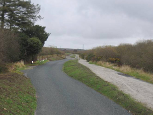
After the Scheme was completed, the old A30 was downgraded and, where it crosses the Goss Moor, facilities provided for walking, cycling and an equestrian route, as part of a network of multi-use trails being established by Natural England around the wider reserve. This will effectively rejoin the two parts of the moor, providing benefits for a number of species, in particular the Marsh Fritillary butterfly, by increasing the quality and quantity of breeding habitat and enabling colonisation of sites by reducing isolation.
Sustainability
Over 98% of the imported stone used for the entire works was sourced from the china clay industry, thereby utilising a waste product available in abundance in the vicinity of the site. With the china clay industry in decline, the use of this waste material provided an economic benefit to the local community in difficult times.
A mobile coating plant for the surfacing was established at the source of the secondary aggregate, further minimising transport impacts through local villages.
Existing roads that were no longer required have been planed and the chippings reused for access tracks.
All vegetation and roots cleared were chipped and reused as mulch.
The scheme was carefully designed to have an exact balance of cut-and-fill, negating the need to import or export material.
Community
Early consultation with Natural England, Cornwall County Council, the Environment Agency, local Parish Councils and various community groups continued through the construction process, ensuring close and successful public involvement through a dedicated liaison process. This involved regular presentations to schools, professional bodies, educational, local interest and environmental groups and operating a continual series of site tours as work progressed. Regular support initiatives for local charities culminated in a sponsored walk through the scheme prior to road opening, which attracted a county-wide involvement, raising over £14,000 for local charities.
As part of the archaeological site investigation, groups of students were invited to become actively engaged in excavation works.
The success of this scheme was built on robust and continuous consultation. The design and construction adopted a holistic approach in trying to understand the many varied aspects, constraints and opportunities in order to deliver effective environmental mitigation that will provide lasting benefits to the environment, economy and people of Cornwall.
Roads Minister Stephen Ladyman said: "Pioneering work on the A30 Bodmin to Indian Queens scheme shows how we can reduce the environmental impact of a major road project. It is an excellent example of finding a local solution which benefits local people, the local economy, the landscape and the environment.
 |
|
