Sunderland Strategic Transport Corridor (SSTC) – New Wear Crossing |
|
Client & Design Award
Project Team:
Client: Sunderland
City Council
Design: Sunderland
City Council, Spence
Associates, Techniker,
Roughan O’Donovan,
Jacobs
Construction: N/A

(L-R) Kate Cairns, (CEEQUAL Assessor); Jonathan Coffey (Sunderland Strategic Transport Corridor New Wear Crossing Project Manager, Sunderland City Council); Ron Odunaiya (Executive Director, Sunderland City Council); ICE President Richard Coackley; Councillor James Blackburn (Portfolio Holder) and David Abdy (Sunderland Strategic Transport Corridor New Wear Crossing Project Director, Sunderland City Council).
The Project
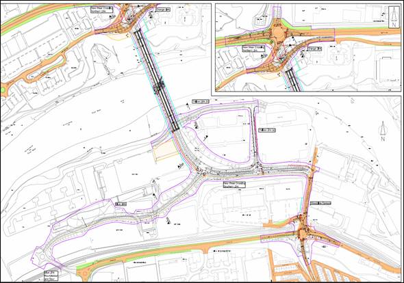
The New Wear Crossing comprises a new multi-user bridge across
the River Wear with connections to the existing highway network.
It includes upgraded signalised junctions to facilitate bus
priority at A1231 Wessington Way on the north side of the
river and a signalised junction providing connection to European
Way and Pallion New Road on the south of the river, as illustrated
in the General Arrangement below.

New Wear Crossing – General Arrangement
The bridge design aims to fulfil Sunderland’s broader regeneration objectives by creating a symbol of the city’s economic and regeneration aspirations, and thus raising the profile and confidence of Sunderland as a place to invest. It will provide Sunderland’s residents, and the wider region, with a high quality architectural feature that will be highly valued as a symbol of increasing local confidence and aspiration.
The scheme is part of the proposed Sunderland Strategic Transport Corridor (SSTC), first identified by the Council in its 1998 Unitary Development Plan (UDP). The construction of the SSTC is a key feature in attempts to regenerate the city in line with the Sunderland Economic Masterplan.
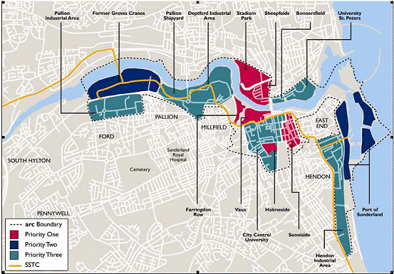
The overarching strategy is to implement the programme over five phases in order to optimise the funding requirement. Whilst each phase has been prepared on the basis of being a stand-alone project, there are interdependencies between each of the phases and development of the regeneration sites that will benefit from the new accessibility and linkages.
A number of development sites from the Port of Sunderland, through the city centre to Pallion further west will therefore each play an important role in delivering the ambitions expressed in the Sunderland Economic Masterplan (see map below).

Priority Development Sites
Full development of these sites would bring somewhere in the region of an additional 6,000 jobs to Sunderland.
Bridge
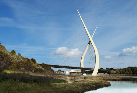
The New Wear Crossing will provide a new 336m span bridge, built to quality that will provide a ‘landmark’ structure for the area. The overall design reflects a minimalist structure which represents a powerful symbol of Sunderland’s renaissance.

Landmark Design
Its design is truly striking, with two independent curving concrete and steel composite masts, with stays supporting the deck from one side of each mast only. At Programme Entry in 2008, the tallest mast had a proposed maximum height of 210m, although subsequent design refinement has resulted in masts with heights of 187m and 137m. The masts, sited within the riverbed with foundations below water level, will be of steel clad reinforced concrete and varying geometry. Thus, it will constantly reduce in size as they reach their highest points.
The bridge will carry vehicular traffic on a dual carriageway with two lanes in both the northbound and southbound directions, with dedicated provision for pedestrians and cyclists. The 24.5m width bridge deck comprises: a 4m width shared use footway/ cycleway adjacent to the northbound carriageway; two 7.3m width carriageways separated by a 1.8m central reserve; and a 2m width footway adjacent to the southbound carriageway.
Functional lighting for the bridge will include pedestrian footway/ cycleway and aircraft navigation lights at the top of each mast. In addition, minimalist feature lighting will be used to illuminate the mast’s (mainly inner) facades through light and shade. The artist’s impression below shows the feature lighting used to illuminate the masts at night.

Bridge Feature Lighting
Highways
The scheme includes approximately 3.2km of new highway which will provide the necessary connectivity between the existing road infrastructure and the new crossing. All the links will provide pedestrian and cycle access, in the form of shared use footways, either single or both sides of the carriageway.
Landscaping and ecology
Significant landscaping & ecology works are included
as part of the scheme. The majority of the site is brownfield
land; however the bridge does cross over an extensive area
of saltmarsh and mudflats on the north bank of the river,
which is designated as a Site of Nature Conservation Interest
(SNCI). Habitat creation works are being undertaken to mitigate
the loss of saltmarsh and river-bed habitats.
Procurement of a contractor is due to take place in 2012,
subject to funding, with construction due to start at the
end of 2012.
More information can be found on the project website www.newsunderlandbridge.com

